The New Zealand Wind Energy Association (NZWEA) welcomes the passing of the Offshore Renewable Energy Bill, describing it as a significant milestone for New Zealand’s renewable energy transition.
NZWEA Chief Executive Kevin Hart said the legislation provides the regulatory certainty needed to unlock investment in offshore wind energy which is needed to support Aotearoa New Zealand’s fast growing electrification needs.
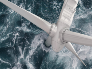
“This legislative decision establishes the framework the industry has been waiting for. A clear ‘two-step’ permitting regime gives developers greater confidence to investigate and invest in New Zealand’s exceptional offshore wind energy resources. With high-capacity factors similar to that of hydro generation, offshore wind energy provides a complimentary energy source to the grid when we need it most.”
As electricity demand continues to increase, offshore wind energy has the potential to play a crucial role alongside onshore wind and other renewable energy sources in delivering a secure, affordable and low-emissions electricity system.
The new legislation introduces a two-stage permitting process, allowing developers to undertake feasibility investigations before progressing to commercial development, while ensuring projects meet environmental, safety and decommissioning requirements.
“New Zealand is fortunate to have world-class offshore wind resources, particularly in the South Taranaki Bight. This legislation provides the foundation for responsibly assessing and developing that potential over time.”
NZWEA acknowledges the leadership of the Government, Energy Minister Hon. Simeon Brown, and former Energy Minister Dr. Megan Woods, all Iwi including Te Runanga o Ngati Ruanui Trust, Te Korowai o Ngāruahine Trust, Te Kotahitanga o Te Atiawa Trust, MBIE officials, and also industry stakeholders including Venture Taranaki, Taranaki Offshore Partnership and NZ Offshore Wind Limited (NZOWL) who have tirelessly contributed to developing the new regulatory framework.
“The passing of this Bill is an important first step. We now look forward to working with Government, iwi, regulators, communities and industry as the permitting process is implemented and the first feasibility rounds are made available.”
“With the right framework now in place, Aotearoa New Zealand is well positioned to explore how offshore wind energy can contribute to our future energy security and economic prosperity.”